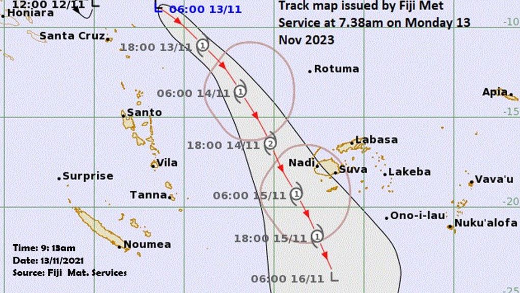
The Nadi Weather Office says they are anticipating Tropical Disturbance TD02F to become a Tropical Cyclone in the next 6 to 18 hours, and we are expected to feel further effects from tomorrow into Wednesday.
The centre of the Tropical Depression is located 1,000 kilometres West North West of Rotuma or 1,300 kilometres North West of Yasawa I Ra.
Based on the current forecast track, the cyclone is expected to pass to the West of Viti Levu with a possibility of landfall on the Western Division.
It is expected to be a Category 2 Cyclone when it affects most of the Western Division.
The weather system is expected to move South East eventually away from the group in the next 2 days.
They say the onset of Gale Force winds is expected to affect Yasawa from midday tomorrow and gradually spreading to the rest of the group.
This means damaging winds and cyclone impacts could begin several hours prior to the cyclone centre passing over or nearby.
Please secure your homes and properties and know your evacuation centres.
A Flash Flood Alert is now in force for flood prone areas, small streams and low lying areas within Bua-Lekutu, Dama, Solevu, Wainunu to Kubulau, Wailevu West Coast, Savusavu, Coastal Vaturova – Koroalau; Upper Wainimala, Koro Island, Ovalau Island and Tailevu North.
This means flooding of roads, Irish crossings and bridges in low lying areas and flood plains.
A Gale Alert remains in force for Rotuma.
A Storm Alert remains in force for Yasawa and Mamanuca group, Western, Northern and Southern Viti Levu, Vatulele, Kadavu and nearby smaller islands.
A Gale Alert remains in force for the western half of Vanua Levu (Dreketi, Bua to Savusavu), Eastern Viti Levu and Lomaiviti group.
A Strong Wind Warning remains in force for the rest of Fiji.
A Heavy Rain Warning remains in force for the whole of the Fiji group.
An active trough of low pressure with associated cloud and rain is affecting the country.
The Weather Office says for Rotuma, expect strong Southeasterly winds up to 45 kilometres an hour with gusts to 80 kilometres per hour with winds increasing to 65 kilometres an hour with gusts to 90 kilometres an hour from early tomorrow.
They also say there will be periods of rain, heavy at times and a few thunderstorms with rough to very rough seas.
For Yasawa and Mamanuca group, Western, Northern and Southern Viti Levu, Vatulele, Kadavu and nearby smaller islands expect strong Southeasterly winds up to 45 km/hr with gusts to 80 km/hr, and winds increasing to 95km/hr with gusts to 130km/hr and becoming clockwise from later tomorrow.
There will be periods of rain, heavy at times and a few thunderstorms with rough to very rough seas.
For western half of vanua levu [Dreketi, Bua to Savusavu], eastern Viti Levu and Lomaiviti Group expect strong Southeasterly winds up to 45 km/hr with gusts to 80 km/hr with winds increasing to 85km/hr with gusts to 120km/hr and becoming clockwise from later tomorrow.
For the rest of the Fiji group expect strong southeasterly winds up to 45 km/hr with gusts to 80 km/hr. winds increasing to 55km/hr with gusts to 80km/hr and becoming clockwise from later tomorrow with occasional rain, heavy at times and few thunderstorms over most places.
There might be localised flooding of susceptible communities, businesses and low lying areas.
Also localised flooding of minor roads, Irish crossings and bridges with some disruption to traffic flow. There will be poor visibility at land and sea with increased risk of motor vehicle accidents due to slippery roads.
Possible impacts due to expected tropical cyclone from later tomorrow with significant damage to houses of very light materials and old galvanized iron roofs blown off.
There is also a risk of disruption in communication network and power supply due to damaged power lines.
Most plants and crops are expected to be damaged and downed with a few small trees broken and blocking roads with major disruption to traffic flow.
There might be flooding of roads, settlements, properties and infrastructure near streams and river banks with displacement of communities near streams and river banks due to flooding with danger to life
Also localised disruption of essential services with a very high risk of sea travel for all types of sea crafts
Source: Fijivillage.com.fj