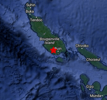
A 6.3 magnitude earthquake struck the Southern part of the Autonomous Region of Bougainville this morning around 6:13am.
As per report from the Port Moresby Geophysical Observatory (PMGO) of the Department of Mineral Policy and Geohazards Management, the earthquake occurred as a result of the interaction between the Solomon Sea Plate and the Pacific Plate just 155.46 degrees E, 6.88 degrees S , and 62km South of Panguna.
It is of tectonic origin thus it was felt strongly in southern part of the Autonomous Region of Bougainville
Mr Felix Taranu Principal Seismologis from the Port Moresby Geophysical Observatory (PMGO) of the Department of Mineral Policy and Geohazards Management highlighted that the earthquake occurred near the coast, however, the potential for tsunami generation is very low.
There were reports of strong shaking within the localities of Aitara and Tokuaka, which is less than 10 km away from the earthquake epicentre.
Also, according to Earthquakes Live the moderate shaking probably occurred in Panguna (pop. 2,900) located 55 km from the epicenter, Arawa (pop. 40,300) 65 km away, and Kieta (pop. 3,600) 68 km away also.
Shallow earthquakes are felt more strongly than deeper ones as they are closer to the surface.
The exact magnitude, epicentre, and depth of the quake might be revised within the next few hours or minutes as seismologists review data and refine their calculations however there is no other addition new information at this time yet regarding the earthquake.

